


We got away from the dock at 1. Our first stop was the fuel dock. It’s about 2 miles south of our berth. This required us to go in the opposite direction to where we wanted to go. At one point I considered reversing the direction I was planning to go just so backtracking would not be necessary. I wanted to experience the Monument wilderness last though so I kept to my original plan. But I hate to backtrack so I wasn’t real happy with the four mile trip to the fuel dock and back.
Then I had to decide what to fill. A little explanation is in order. Blue Note has 4 tanks, two 40 gallon tanks and two 35 gallon tanks, for a total of 150 usable gallons. The problem with the way this is set up is that the venting to the tanks is inadequate. The result is that some of the tanks are easier to fill than others. One of the tanks that was empty was one of the more difficult ones to fill. What happens is you squeeze the nozzle and a couple of seconds later there’s a geyser shooting up out of the fill port. When the liquid you’re dealing with might as well be gold, this is not what you want to happen. To add to this, when the geyser spouts, it ends up in the water, creating sheen. When the Coast Guard has a huge facility a couple of hundred feet away from where you are refueling, this is something you really don’t want either.
An hour and a half later we were on our way. The weather wasn’t great, overcast, 10 knots on the nose, and occasional rain squalls. Our destination for the night was Loring, a tiny village whose draw was a dock with a free float, at least according to the Forest Service information I had. I raised sail when we turned up Clover Pass and we motorsailed the rest of the way.
One of the things I noticed on this leg of the trip was the vast number of houses on the beach in Clover Pass. I’m not talking cabins and resorts although there were plenty of those. No, I’m talking houses, big houses with multiple floors, outbuildings, decks, docks with ramps and floats. The fortunes these dwellings represent was staggering and to top it off most showed absolutely no sign of occupation. Must be nice to have a multi-million dollar “cabin” you rarely use.
We got to Loring about 6:30. I wasn’t happy with what I saw. They had a dilapidated float that had no connection to the beach due to missing pilings. The other float was brand new or at least looked it. It was below a huge house replete with a woman standing behind a large picture window with her arms crossed over her chest and scowling at us. Obviously not the free dock the FS was talking about. I went below to read what the Coast Pilot had to say about an alternate anchorage. It mentioned a dock and float in the cove at the head of Naha Bay, the bay we were in. We headed there.
When we turned the corner I could see a couple of sailboats moored to a float. As we got closer I could see it was jam-packed, no room at the inn for us. I still wasn’t absolutely sure if this was the FS dock so I maneuvered close enough to gain the attention of the fellow sitting under the dodger of the nearest boat. He confirmed that it was the FS dock and asked if we wanted to raft up.
After we got tied up and I had taken Jazz ashore I went aboard the S/V Solitude to talk to her owner Orville. He was very kind to recommend some of his favorite places on my route. He, his buddy Telly, and I had a pleasant couple of hours telling stories.
We were away by 10:30 the next morning. Our destination was Klu Bay about 26 miles. The weather was overcast with 10 knots out of the SW, putting it on the nose until we rounded Indian Point. I raised sail and we motorsailed up Behm Canal.
Nearing Neets Bay I could see trollers everywhere. I stopped counting when I got to fifty. I later found out that Neets Bay was a release site for hatchery salmon. For the most part they stayed out of my way even though they had the right-of-way. But there’s a jerk in every crowd and the one in this one kept altering course to be in our path. I finally gave up trying to avoid him, seeing he was a fiberglass boat. I think he saw he would lose the confrontation with a pointy steel boat and veered off. I smiled and waved getting the bird in response.
Approaching the entrance to Klu Bay I was disappointed to see a skiff dart out of the Bay heading for the twin falls that drain the lake above. It probably meant there was already a boat on the FS mooring. Sure enough, a motorcruiser sat at the ball when we rounded the corner. I anchored across the bay but wasn’t happy with the set. I looked at the options and decided to head to a FS mooring in Blind Pass about 10 miles away. If it were occupied there was one up Bailey Bay another 5 miles further. Off we went.
The sun had come out by this time and it was a beautiful motor up to Blind Pass. I could see a large motorcruiser sitting at the mooring in Bailey Bay meaning if the one at Blind Pass were occupied we would be underway for several hours to the next one in Anchor Pass. Fortunately it was vacant and we had no trouble tying up. I launched the skiff and Jazz and I went ashore to explore.
Part of my procedure when scouting an anchorage is to motor around, surveying to see what the depth, bottom type and swinging room look like. Not knowing what the Forest Service’s criteria were for placing their moorings, I saw no reason to alter my habit. Circling the mooring before tying up, I saw we had 30 feet on the beach side, plenty of water. Never the less, I set the alarm for 6 in the morning as we were to have a -3.1 foot low tide at 7:10.
I was awakened at 5 by a strange noise. Getting out of bed, I could hear wind in the rigging. As I was climbing the stairs to the cockpit I heard the noise again and saw the wheel move. The noise was the rudder scraping in the rocks! We were still 2 hours from low tide. I had to get the rudder clear like right now. I started the engine and jumped behind the wheel. It was locked in place. I couldn’t move it. The wind had blown us toward the shore and Blue Note’s rudder was jammed in the bank. I kicked it in gear and applied throttle. At first nothing happened, then slowly we began to move off the bank. Once free, I swung the boat around to the other side of the buoy and put it in reverse to hold us off the bank while I collected my thoughts.
The mooring in Anchor Pass was the nearest option about 11 miles away but on our intended route. There was no way I wanted to retrieve the skiff in the 20 knot wind howling up Blind Pass so I rigged it for towing. We slipped the mooring at 6 and were underway.
We arrived at the mooring in Anchor Pass a little after 8. I was relieved to see it was unoccupied and sheltered from the wind blowing in Behm Canal. This time I circled it more carefully especially with an eye toward swinging room. Satisfied, we were fast to the buoy by 8:30.
The rest of the day was spent reading, doing crosswords, and taking Jazz to the beach. Oh, and deciding where to go from here. Both Orville on the S/V Solitude and Gary on the S/V Irish Dreamer spoke of the great crab fishing in Burroughs Bay. They also warned that the mooring was totally unsheltered from weather blowing up Behm Canal. I decided to see what the weather was like in the morning and to choose whether to go there or continue on then.
Monday morning dawned clear and calm. We slipped the mooring a little before 10 and motored out into Behm Canal. The wind was light, less than 8 knots and on our stern, sadly too light to gain any advantage in raising sail. Several miles up the Canal we were joined by a pod of Dalls porpoises. They stayed with us for an hour playing in our bow wave. It amazes me how much they raise my spirits.
Arriving at the mouth of Burroughs Bay, I debated whether to proceed the 5 miles up the bay to the mooring or to continue on. The wind was still light, less than 5 knots and the sea was relatively flat. With the thought of fresh crab dancing in my head we headed up the bay.
The Unuk and Klahini Rivers drain into Burroughs Bay. I had read that the Unuk River was navigable by skiff over a mile up from the mouth. My plan was to set the crab pot, tie up to the mooring, and then explore the river. Best laid plans…
By the time we got to the mooring at 12:30, the wind had picked up to 10 knots, kicking up a 2 foot chop. Still it wasn’t too bad if it didn’t get any worse. It got worse. By 3, it was blowing 15-18 with a 4 foot chop. I figured the wind would probably die out in the evening if we could stick it out. Exploring the Unuk was definitely out. It was over a mile away and the seas would soak us by the time we got a ¼ of a mile.
By 3:30, it was gusting to almost 25 knots and the sea was running 5 feet. The motion of the boat reminded me of the outside of Dall Island. By this time the boat was banging into the buoy, losing paint in the process and chafing the line. Time to go.
While we were sitting at the mooring, I had watched a crab fisherman pick his pots right in the vicinity where mine was set. He pulled two out of the first one and three out of the second. I thought at least I’d finally catch a crab. Wrong. When I got the pot aboard there was an 8 inch halibut in it, too small to keep. Skunked again.
We headed for Fitzgibbon Cove, right around the corner from Burroughs Bay. There was a spot marked 5 fathoms on the chart that looked suitable. Wouldn’t you know the wind died about a mile from the entrance. Sigh.
As we rounded Fitzgibbon Point, the troller that had been working the waters off Point Whaley was heading for the same bay we were. Given my luck so far this trip, I fully expected to see him anchored in the spot I had picked. I was hugely relieved to see him anchored in the deep basin at the head of the bay. We proceeded to our anchorage and I dropped the hook in 30 feet. I paid out another 60 feet of chain and it set with a satisfying lurch. Home sweet home for the night.
Tuesday was high overcast and calm. Our destination was the FS mooring in Walker Cove. I was a little apprehensive in going there because if it were occupied, I wouldn’t know it until 5.5 miles into the bay, causing an 11 mile detour with the next opportunity for mooring over 20 miles further on. We motored down east Behm Canal and turned into the cove.
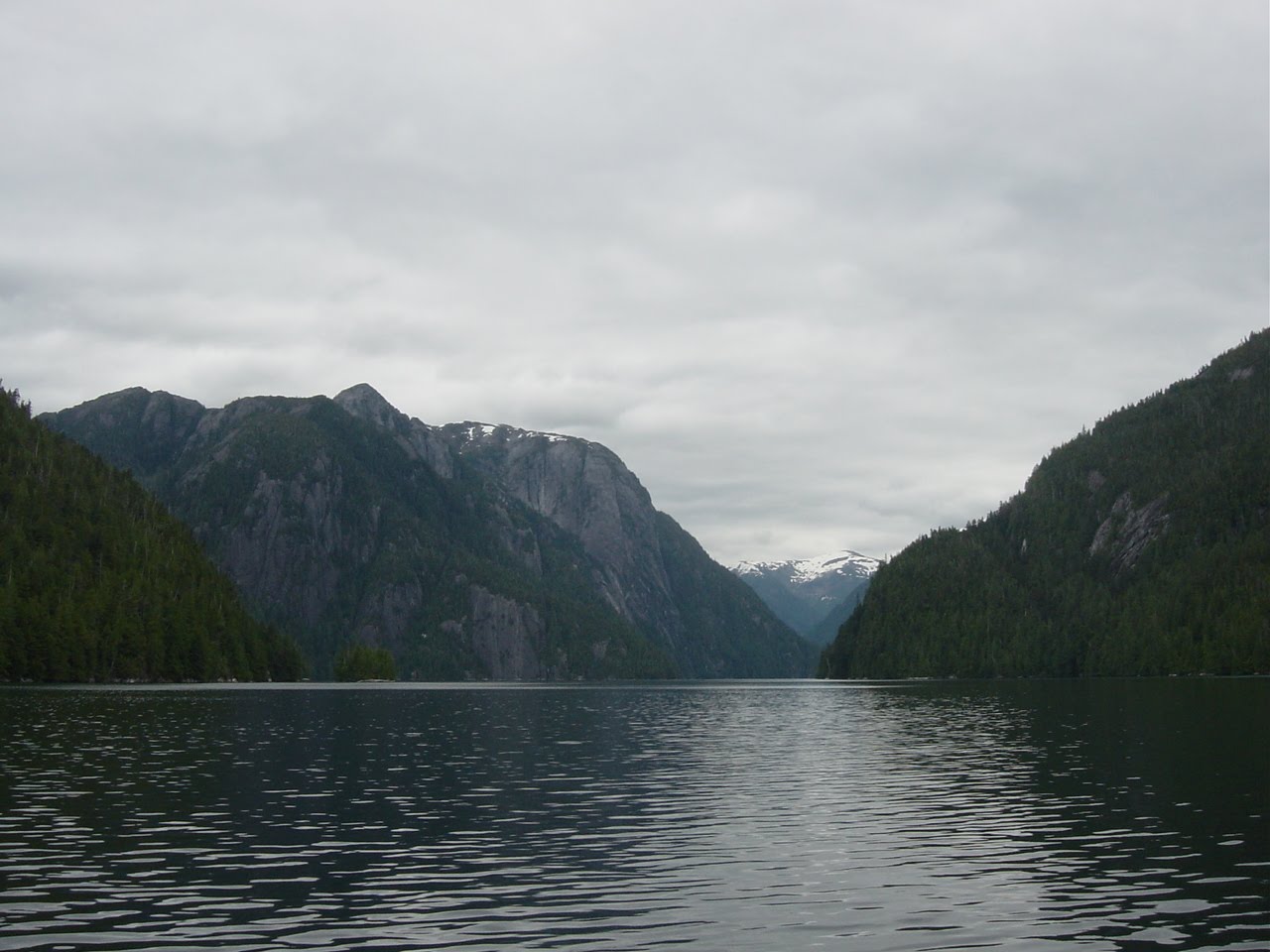
Walker Cove is spectacular with granite cliffs rising straight out of the water, some to over 3000 feet. Even if the mooring were occupied, it was worth it to see the place. On our way in an avalanche of rocks and snow tumbled down one of the glacier-cut ravines. Fortunately the mooring was open. We tied up and spent a relaxing evening watching the clouds burn off and the sun disappear behind the peaks.
Wednesday was overcast again with the tops of the cliffs shrouded in mist. It was calm deep in the bay but as we gained the main channel the wind was blowing from the mouth up the bay at 10-12 knots. Approaching the entrance, the wind was a steady 18 knots and whitecaps could be seen out in the Canal. We had towed the skiff since Blind Pass and were again today. I debated turning around and going back to the mooring or at least back to find enough shelter from the wind to get the skiff secured on board. I decided to head out into the Canal to see what the conditions were.
Rounding Ledge Point I could see the seas were 3-4 feet and the wind was still a steady 18 knots, not the best of conditions but not too bad. The route I had plotted had us hugging the eastern shore of Behm Canal to the entrance of Rudyard Bay. But with the weather right on our nose our speed dropped to 2-3 knots. I decided to raise the main and tack into the wind.
Behm Canal is oriented north-south along this 15 mile stretch and with the wind out of the SSE, we were making one long leg and then one short leg across the over mile-wide waterway. Even with a speed of 5.5 knots motorsailing with a single-reefed main our VMG was still only 3.5 knots and the ride somewhat uncomfortable. I began to look for an alternative.
Manzanita Bay on the western shore looked like it might be one. It was at the end of one of the long tacks, it was sheltered from the wind, and though very deep right up to the shoreline the chart showed a mooring buoy at its head.
A mile from the bay we were in the lee of the island. I hadn’t realized how on edge I was until the waves dropped and the wind moderated. I’m never comfortable towing the skiff and in these conditions it was worse. I was looking forward to getting tied up and relaxing.
Clearing Wart Point (what a name) I began looking for the buoy. All the ones I had seen so far consisted of a partially submerged float, girded by a tire serving as a fender, with a 2 foot post topped with a ring. They had been painted white, making them not too difficult to spot. I couldn’t spot this one. I grabbed the binoculars and scanned the shore and still couldn’t find it. I read the Coast Pilot and it described the bay with its mooring buoy. Then I looked at the Forest Service map. It did not show a mooring in Manzanita Bay. Apparently between the time the chart had been updated 2 years ago and this season, the FS had removed the mooring. Oh well, back out into the Canal.
Re-rounding Wart Point, I was happy to see that we were far enough south that we could make it directly to Rudyard Bay without having to tack. About a half hour into the 2.5 mile run and with a sinking heart I spotted a motorcruiser making for Rudyard Bay. Silently urging him to continue northward, he defied my wish and disappeared into the Bay. At this point in my trip through Misty Fjords I was disgusted with the whole thing and contemplated simply turning south and heading back to Ketchikan non-stop. But we had gotten this far and Punchbowl Cove in Rudyard Bay was purported to be the crown jewel of the Monument. Jazz was cocking his head and looking at me with a funny expression as I cursed the gods sotto voce. We continued on.
We rounded the point at the entrance to the Cove and sure enough there was the motorcuiser I had seen earlier at the mooring buoy. To make matters worse, the tops of the sheer granite cliffs were still shrouded in clouds. What a bust all the way around. I still had the sail up and in the fluky winds this far back in the bay I had my hands full keeping it from gybing and luffing. When I finally got the boat turned around I noticed the other boat was moving up the eastern shore of the cove. The mooring was vacant! I apologized to the gods and turned back for the buoy.
When the boat had been secured Jazz and I made our way to the beach for his business. The ideal landing spot for these sojourns is steep enough to allow the skiff to be re-launched with little difficulty but not so steep as to make getting in and out of the skiff a wet proposition, not rocky so Jazz’ pads don’t get cut up on the ubiquitous barnacles and mussels, and not muddy so he doesn’t track it all over both the skiff and the boat. Less than an 1/8 of a mile away there appeared to be the ideal landing spot. We headed over there and it was the best beach we had found ever. Perfectly sloped and free of rocks it consisted of what looked like black sand but was small grains of the surrounding granite. It didn’t even stick to his paws. It says something about Misty Fjords Monument when the high point is finding the perfect beach for Jazz to poop on.
After the perfect beach we motored over to the stream that drains the lake above the cove. Now it was time for me to curse my own stupidity in not taking my camera for right on the beach next to the creek was a big grizzly sow and her 3 cubs foraging in the grass and seaweed. We floated about a hundred yards off the shore and watch them for about 45 minutes. They finally ambled back into the woods and we returned to the boat.
Remember I said that Punchbowl Cove was supposed to be the crown jewel of the Monument? Well it is very pretty, kind of a Yosemite Valley if the valley floor had been flooded with saltwater. This opinion seems to hold great sway with every float plane jockey in southern Southeast because everyone of them makes at least 3 trips through the cove daily. On intervals of less than a minute and sometimes two at a time they roar through at low altitude. Few things are less peaceful than the growl of a nine-cylinder DeHavilland Beaver radial or the scream of a Cessna 206 Lycoming.
Occasionally they land. One did that Thursday morning as I was readying the boat for departure. They are quiet at low throttle settings and this guy cruised past us on the water making for the stream where we had seen the bears. The tourons on board all got out on the float as the plane drifted just off the beach snapping pictures and pointing. Then they all piled back in and the pilot fired up the engine and turned the plane out to the entrance. Then instead of taxiing back out past us he fire-walled the throttle and thundered by no more than 150 feet away. I felt like mooning them but thought better of it as I remembered the six-inch letters emblazoned on each bow proclaiming the boat name.
We headed for Alava Bay. I’d had my fill of the vaunted Misty Fjords. Besides I was running low on medicine and wound packing. But most importantly, I only had a couple of day’s worth of coffee left. The day was sunny and the winds were light. Rounding the point into the bay I saw a fish tender where the mooring was supposed to be. Figures…an unhappy ending to an underwhelming trip. As I got closer I spotted the buoy behind the fish buyer. Yay! After tying up and taking Jazz to the beach I had too many gin and tonics and went to bed early.
Friday I loaded the skiff on the back deck and we were underway by 8:30. It was overcast but promised to burn off. It did burn off but the winds were once again light and we motored the whole way. We were tied to the dock in Bar Point Harbor by 1:30.
My recommendation for Misty Fjords National Monument: do not visit it by boat while the cruise ships are calling on Ketchikan and the float planes are flying. Instead go over to the dark side and do what the tourons do: visit it by float plane.
The pics: one of the weekend cabins in Clover Pass, the mooring at Blind Pass the night before going aground, the Fitzgibbon Cove anchorage, Walker Cove, one of the 3000 foot cliffs in Walker Cove, the mooring in Walker Cove, the wall in Punchbowl Cove, the perfect beach, New Eddystone Rock which is the core of a volcano that rises 900 feet from the ocean floor and is 260 feet above the ocean surface, Alava Bay.
ap

No comments:
Post a Comment