


What a run up Chatham Strait! We left Port Alexander under mostly cloudy skies and light winds. The seas were 2-3 feet with the occasional 4 footer out of the south. The forecast was for northerlies to 15 knots. My plan was to make for Warm Spring Bay 55 miles away depending on the conditions. I figured if the winds didn’t cooperate we could put in to any one of a number of good anchorages on the way.
Coming abeam Point Conclusion the winds were out of the northwest at about 5 knots. The batteries were low after almost two days at the dock in PA so I didn’t mind the light winds and Miss Mercedes grinding away. But wind is wind and these winds weren’t on the nose. I set the main and got almost a knot. As we moved past Port Conclusion the wind backed to the ENE. I let Otto steer and trimmed the main to the shifts. It proved to be the predominate pattern, with the wind more northerly as we approached one of the deep fjord/canyons indenting the east coast of Baranof Island, then shifting to the east as we went past.
To take advantage of the flood current and minimize the wind shifts I altered course out towards the middle of the Strait. Blue Note has two speed indicators: one is a paddlewheel under the hull, the other is the GPS. The GPS shows SOG, Speed Over Ground, which is the speed you are realizing along the track. The paddlewheel or more properly the speed log shows the speed of the hull through the water. The difference between the readings indicates the effect current is making on your progress. At the peak of the flood, the speed log was 1.5 knots below SOG, indicating a knot and a half boost to our forward progress.
Toward late morning the wind had freshened to 8-10 then 10-15 with gusts to 20. I unrolled the genoa. As I trimmed it in the engine began to pick up speed as the sails took the load. I watched the SOG as I throttled the engine back. It dropped from 8.2 to 7.5 at idle. I shut it off in spite of the low batteries. Aah quiet. Well not really. But bliss for sure. The wind in the rigging, the burble of the wake, and the intermittent grunt of Otto’s pump moving the rudder to keep us on course combined with 7-8 knots of speed made for a wonderful three hours.
As the day wore on the wind began to die. Reaching the mid point of the joining of Chatham Strait and Frederick Sound the tide changed. We had been motor-sailing for several hours making 5-6 knots and charging the batteries. I knew that as the ebbing current increased we would be fighting it under motor alone. I tucked in close to shore to minimize the current effect. Good call. There were several pods of humpbacks fishing in the area and the clouds had gone for the most part. We were alongside the dock in Baranof by 8 PM, having averaged almost 6 knots for the run!
We spent five days in Baranof. The good weather and great company kept us tied to the float. The days were spent soaking in the spring, hiking to the lake, meeting new friends, and in general just hanging out. I had already met John on the S/V Sara. He was busy moving back into his house in Baranof. I met Dave and Anke on the S/V Slacktide. They had just finished 7 months of caretaking the Baranof Wilderness Lodge and were readying their boat, a junk-ketch-rigged sailing barge for a summer cruise. Tom on a Roberts 38 was headed up to Glacier Bay to work as a pilot boat operator for the summer. The M/V Explorer IV, a 60 foot motor yacht crewed by a bunch of fun-loving Canadians from Whitehorse passed through on their way to Skagway.
As the days slipped by I began to rethink my next route and destination. Those of you who have been following this blog know my planned route from here was the reverse of the route I took when I left Petersburg last November, i.e., back through Frederick Sound. From there I planned to go down through the Wrangell Narrows to Wrangell. When I looked at the calendar I realized that if I reversed destinations and went to Wrangell first I would be in Petersburg for Little Norway Days, a fun time to be in Petersburg.
The shortest route to Wrangell goes through Rocky Pass in Keku Strait. My 2008 edition of Charlie’s Charts, a popular inside passage cruising guide says that Rocky Pass cannot be used because the navigation aids have all been removed. But my ten year old charts and six year old Coast Pilot Vol. 8 both show and describe the Pass in close detail. All the captains I talked to in Baranof had gone through several times, Tom on the Roberts and Craig on the Explorer IV just in the last day or two. They all said the nav aids were still there and that it was no problem. I pulled out the tide book.
Rocky Pass is the narrowest and shallowest section of Keku Strait, a N-S body of water separating Keku and Kupreanof Islands and connecting Frederick Sound to Sumner Strait. It shares tidal current characteristics with other N-S narrow channels: both flood and ebb tides flow to and from a center point from each end. The trick becomes arriving at that center point at high slack. That way you ride the flood tide current to the center point then ride the ebb current out the other end. There is a downside to this plan.
According to the Coast Pilot the center point is at various points between High Island and Summit Island. If you are travelling south and arrive at the tidal center point at high tide, you are on a falling tide when you get to Devil’s Elbow, a little over 2 miles south. Devil’s Elbow is a right angle turn where the channel is quite narrow and swinging wide or cutting the corner is not advised. I wanted the cushion of a rising tide through the Elbow in case I got stuck in the mud and was willing to sacrifice having to buck the current for a couple of miles to have it.
Further research revealed Stedman Cove to be a suitable layover anchorage. I plotted a route to there: 44 miles. A check of the tide book indicated a departure of a little before noon on Thursday would allow us to ride the ebb down to Point Gardiner, then the flood all the way to Stedman, arriving before dark. A plan with a departure time set I went next door to the Explorer IV to have dinner with the Canadians.
What a good time! Bombay Sapphire G & Ts, an excellent red, and one of the best steaks I’ve had in a long time complemented great conversation. One of the guys shared a similar work history with me and pretty soon we were swapping helicopter exploits and radio stories. One thirty came in no time. Good thing the sailing board was set for noon.
I missed Thursday’s dawn but it was nice by the time I rolled out of the bunk. After saying good bye to all my new friends and readying the boat for departure we left. I raised the main as we motored upwind down the Bay. The forecast was for northwest winds to 10 knots in both southern Chatham Strait and Frederick Sound. Turning the corner into Chatham Strait we got 10 knots out of the south. The wind lasted until we got to Point Gardiner then died. We motored across Frederick Sound with the wind filling in slowly from the northwest behind us. By the time we reached Cornwallis Point it was barely enough to keep the sails full. Two hours later we were at the entrance to Stedman Cove.
There are pitfalls to using electronic chart programs. One of them is that you are rarely looking at the whole chart. I am almost always looking at a small portion centered on where the GPS has located the boat. Even when I zoom out, I’m either not looking at things like the title area or the text is too small to read. With NOAA Chart 17372, this is a mistake. Unlike almost every other NOAA chart I’ve used, the soundings on 17372 are in feet instead of fathoms.
Imagine my surprise when after getting a little off course entering Stedman Cove the scare box was showing 10 feet. I looked at the chart and the boat was next to a 6. In a flash it dawned on me that the soundings were in feet! It explained why the Coast Pilot described the anchorage depth in feet instead of fathoms. Luck jumps to the rescue of stupidity again. We lived.
It probably doesn’t need to be said that with my increased knowledge of Chart 17372, I went back over my plotted route through the Pass that night. I always plot the deepest route so I didn’t change it by much but I did gain new respect for the morning’s navigational task.
Friday started out with clouds covering most of the sky but the forecast was for partly cloudy turning to partly sunny. The anchor was aboard by 6:30 and we were on our way. I had come up with the departure time based on a SOG of 4 knots. Once we were out in the channel I realized I had underestimated the effect of the flooding current. At the usual RPM setting we were making 5.5-6 knots. I throttled back, not wanting to be going that fast if I made a wrong turn.
There were a lot of turns. The route I had plotted had 85 course changes between Stedman Cove and Eagle Island. Remembering the horror stories I used to hear when I lived in Petersburg along with the comment in the Coast Pilot about the uncharted hazards on the edges of the channel, I really wanted to stay in the channel.
After a couple of hours, I relaxed enough to not panic when I saw 12-15 feet on the box or jagged brown rocks close enough to spit on. The bird life was intense. I spotted a harbor seal and a couple of river otters but not much else. The winds were calm and the clouds were clearing.
The approach to Devil’s Elbow from the north is on an easterly course across a reef that ranges from 6 to12 feet deep at mean lower low water. We were 20 minutes before high slack water. The box was indicating 15-25 feet on the approach. The turn to the south was easy to discern from the two green daymarks and a red can and we cruised right through.
We were out of Rocky Pass by a little after ten. I put Otto to work and began looking for an anchorage for the night. Red Bay looked to be a good one so I plotted a route to its mouth. The wind had picked up to 10 knots south. I set the main and we reached across Sumner Strait.
The entrance to Red Bay was a reprise of the morning’s activities but much shorter. We were anchored in the outer bay by 3:30. I launched the skiff and took Jazz to the beach. When we got back to the boat I decided to re-anchor in the back bay. I wasn’t comfortable with the way the anchor had set and the spot was open to the westerly wind that was blowing 10-12 knots. We moved. I felt much better when the anchor set in the gray mud with a satisfying jerk. After dinner Jazz and I explored the bay in the skiff. Back on board I had a G & T and watched the sun go down from the foredeck.
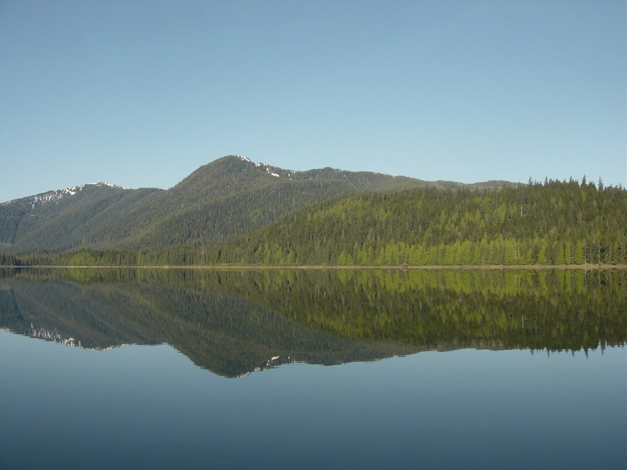
Saturday morning was gorgeous, the bay a huge mirror. We had a leisurely morning getting ready for departure, our destination Wrangell, a little more than 38 miles away. By the time the anchor was in its chock the wind had picked up to about 10-12 knots. I raised the main hoping to at least motor-sail through Sumner Strait. Alas, the wind died once we were out in the Strait and didn’t really help our progress all day. But it was warm and clear with big cumulonimbus clouds hanging over the islands. We were tied to the transient float in Wrangell’s north harbor by 6 PM.
The pics are the sailboats in Warm Spring Bay, a particularly narrow spot in Rocky Pass near the Summit, looking back after transiting Devil’s Elbow, the intrepid crew enjoying the sunset in Red Bay, the huge mirror, clouds over Zarembo Island, and the approach to Wrangell.
ap
