Monday, July 26, 2010

Fun in Ketchikan


Back in Port Bazan I had noticed my left pant leg was wet but hadn’t paid it much attention.  When moving around the boat and doing things, this is a normal occurrence.  Then I noticed the top of my left sock was crusty.  This isn’t a normal occurrence.  I pulled up my pant leg.  The scab had come off where I had barked the shin two months earlier and the wound was oozing.  I figured it would dry up in a day or two so I swabbed it with alcohol and put a band aid on it. Then I promptly forgot all about it.
A few days later I pulled off the band aid, swabbed it again and re-bandaged it.  By the time we got to Ryus Bay, it was red, swollen, and still oozing.  Definitely infected.  I figured I’d go to the clinic, get a prescription for antibiotics and that would be that.
I debated blowing it off but thought I’d better take care of it so Friday morning I set out to do it.  After an hour of walking to several places that claimed to be clinics but didn’t have anybody that could prescribe medicine I finally got to one that could.  They didn’t have any appointments but offered a nurse to look at the wound to see if I should see a doctor.  She took one look and said I should definitely see a doctor.  Serendipitously as I was leaving the receptionist said they had a cancellation and could I be back that afternoon.
After I had described the circumstances under which I had injured it (for about the fifth time) to the doctor and he had examined it, he said he wanted to do a culture.  While he was taking the swab he said he also wanted me to go next door to the hospital to have an x-ray and a blood test.  And he wanted me to see an orthopedic surgeon.  I don’t have health insurance so I said, “Go easy on me, Doc.  This is coming out of my pocket.”  He looked up and replied, “You want to lose your leg?”  That got my attention.  He went on to explain that if the infection has gotten into the bone there wasn’t much they could do. I went next door.
Now was I pretty sure the bone wasn’t infected but that doctor had scared me.  Right after it happened while I was cleaning the wound I also checked for dents and divots in the bone.  There were none.  And if it had been broken, I would have experienced pain that would have prevented me from doing what I had done immediately after.  But I’m not a doctor.  Needless to say, the weekend wasn’t much fun.
Monday morning a nurse called to say the x-ray had been examined and there was no indication of any infection.  Whew, what a relief!
Tuesday afternoon I went to see doctor number two.  He turned out to be a pretty cool dude (the other guy had the bedside manor of Attila and the usefulness of a traffic cop).  He said the infection was a staphylococcus strain that was vulnerable to every antibiotic except penicillin, a very good thing.  He added that the hematoma I had gotten from the blow had left a cavity under the skin and that was where the infection was.  He said if it were his leg he would have it cut open, cleaned out, and let it heal from the bottom up.  The danger was once again the bacteria getting into the bone, the idea being to remove any trace quickly.  I must have looked funny because he then said, “The operation would have to be done in the hospital.  You’re looking at $6000 minimum.”  Ouch, will this roller coaster never end?  I asked if there was a plan B.  He said,”Yeah, there’s packing.”
Packing is a medical term I wasn’t familiar with so I asked.  He told me not to worry; he was going to show me.  The nurse knew what he was talking about because she quickly appeared with a bunch of stuff.  He proceeded to jam about 6 inches of this white ribbon into the wound with a single-ended Q-tip, using the wooden end.  Whoa, creepy.  And a little painful.  We were done, at least for that day; he wanted to see me again in a couple of weeks.  I left with a baggie full of “packing material” and a prescription refill.
Boy was I having fun in Ketchikan.  My plan was to be here for about a week taking care of stuff then taking off for an open-ended cruise around Revillagiggedo Island (the island Ketchikan is on) and through Misty Fjords National Monument via the Behm Canal.  The trip is about 130 miles and I figured I’d be gone up to two weeks before returning to Ketchikan to prepare for transiting British Columbia.  But this stop was proving to be very expensive.  I estimated my medical entertainment at $1k or more and I still hadn’t dealt with the nav computer issue.  I was able to resurrect the autopilot remote.  At least I didn’t have that $2k expense hanging over my head.
I decided to put off the nav computer issue and get ready for the Misty Fjords trip.  What followed was 3 days of jaunts to the grocery store, liquor store, chandlery, and several other places I’ve mercifully forgotten.  Friday looked good for departure.
More later.
I haven’t included any pics as I didn’t take any of my leg and they would be kinda gross if I had.
ap

Postscript: I forgot to mention a person who, without even knowing me went out of her way to help me with a chore I had no means of performing by myself.  Thank you, Joni.  You're an angel.

Oh yeah, I do have a couple pics to post.  These things cruise past the boat all day.  This one is named after you, Jilly.

Nina to Ketchikan

We stayed in Nina Cove for two nights. Not only the security of the Cove after the last six days of, shall we say, excitement kept us there. And it certainly is secure. Perfect anchoring properties, 360ยบ enclosure, and geographical location all make for a very snug spot. No, beyond that it is an interesting place to explore with completely different personalities depending on the tide. At low tide it is a rock pile with broad beaches and dry washes separating the islets. At high tide it is deceptively open with navigable water around the islets, only by skiff of course. Fun!

The birds liked the place too. There were four ravens that delighted in chasing each other through the treetops and performing aerial acrobatics the whole time we were there. They didn’t much like us walking the beach though especially Jazz. One of them would follow us along the beach making a raucous racket when ever we were near a particular spot. I was awakened Tuesday morning to what sounded like a loud cocktail party. It was a flock of maybe 25 Canadian geese picking over the mud flats at low water. It was impressive to see them all leap into the air and form up in the characteristic V, flying a few feet above the water, slowly gaining altitude to disappear over the far shore. The ubiquitous alcids, mostly murres and guillemots were floating and diving out in the entrance. There was usually a pair of eagles either soaring over it all or calling to each other from the top of the trees. The only real mar to this was the active clear cut that was mercifully out of sight and far enough away that only the loudest sounds could be heard when it got particularly quiet in the anchorage.

I began to think of where to go from here. The wilderness area set aside east across Cordova Bay on Prince of Wales Island was definitely on the list. I’d had my fill of logging and clear cuts and I was certain there would be none of the former there although it was likely there would be older cuts. Equally distant to the north was the town of Hydaburg, I was running low on a few things and had been out of touch with family and friends for awhile. I figured I could take care of both things, see the town and then head south. I plotted the route and readied the boat for departure in the morning.

We didn’t get away until 12:30. The weather was overcast with a 12-15 knot wind blowing out of the NW. The 5 hour slog up Tlevak Strait seemed long with the drone of the engine and no help from the sails in the headwinds. It was nice to turn NE into South Pass and get some drive from the Dacron. We were tied to the dock in Hydaburg a little after 7.

It was a big disappointment to find that my cell phone didn’t work and no internet connection was available. So much for half of why I was here. Thursday morning I walked into town. I stopped by City Hall to let the harbor master know we were there. I asked if there was a fee for staying. He said no, not until they had performed some repairs and improvements. I chuckled to myself, thinking of the sorry condition the docks were in and that replacement not repair was what was needed. He did mention that some master carvers were working on four new totem poles and that I was welcome to go take a look. I headed there.

The red cedar aroma was detectable a block away. I followed my nose to a warehouse at the head of the cannery dock with a carving of an orca in front. Inside were two older fellows wielding tools and rendering cedar logs into amazing art. They invited me to wander around and see what they had already done. I’ll let the pictures speak.

I was able to get a couple of the items I was low on from the local market so that part of my trip to Hydaburg was successful but I saw no point in extending my stay. I made plans to leave with the tide in the morning.

Friday morning brought a partly cloudy day with light and variable winds. Motoring south in Sukkwan Strait we passed a freighter being loaded with round logs. Admittedly, I’m no expert on the finances of the logging industry but I hate to see the export of round logs. The only logging in Southeast is on native lands performed by logging companies on behalf of the native tribes that own the land and resources through their corporations. It seems to me that that is similar to eating the seed corn. Maybe the native corporations are maximizing their return by contracting the logging and exporting the round logs to Asia, but it takes more than 70 years to be able to log those lands again and some value added milling to the timber would provide a bit more employment to their members than a few long shoring jobs loading the occasional freighter. End of rant.

The winds remained light throughout our trip to Max Cove in the Southern Prince of Wales Wilderness Area. I tossed the crab pot over on our way into the anchorage. After the hook was set Jazz and I went ashore for our usual “exploration”. By this time the clouds had burned away making for a beautiful afternoon in a beautiful cove. Back on board, I fixed a G & T and relaxed in the sun on the foredeck.

I was awakened the next morning by howling and barking. The sunlight was streaming through the portlights as I made my way up on deck. The wild noises were coming from the forest right behind the beach Jazz and I were on the previous afternoon. I watched for a good fifteen minutes after the last barking bout but never saw the animals—wolves judging from the sounds. Jazz’ hackles were up the whole time.

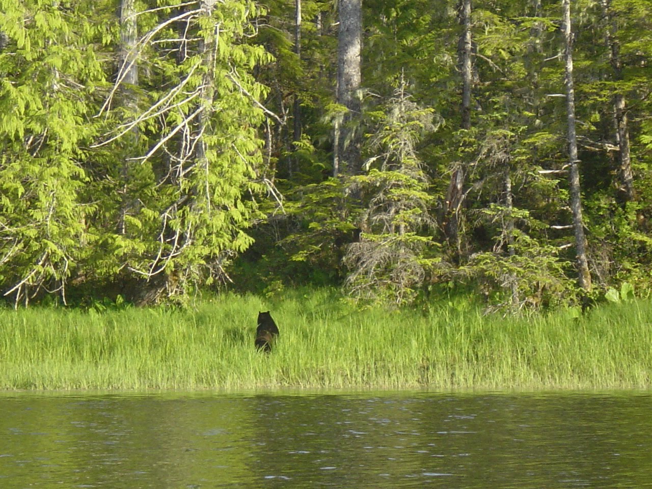
We decided that beach should probably be left for the wild life. The correct choice as that afternoon a black bear decided to root around in the grass on it. I got a couple of pictures from the boat but it was a long shot. I jumped in the skiff and idled closer. The bear heard the motor but couldn’t see me for the sun reflecting off the water. He went back to what he was doing until I shut off the motor about 150 yards away. He could see me by this time and he turned, ambling into the forest. We didn’t visit that beach again.

The weather forecast Sunday morning was for SCA outside, 10 knots building to 20 knots in the afternoon for Dixon Entrance. Monday sounded good for Clarence Strait. I began evaluating the anchorages on the south end of Prince of Wales Island. Minnie Bay looked good on the chart but the Pilot recommended local knowledge for the entrance. Nichols Bay was closer to Cape Chacon but not as sheltered. I decided to head for Minnie Bay, taking a look at the entrance when I got there, traveling on to Nichols if it didn’t look good. I plotted the route.

The routine for getting underway from on the hook has evolved to these steps: start the engine, turn on the depth finder and autopilot, turn on the radar if it’s foggy, move the monitor to the cabin top and set up the nav program to display on both the laptop and the monitor, pull the anchor, and go. I got to the nav setup and saw that the laptop screen was dark. Arg. I determined that the LCD wasn’t working. OK, down to just the monitor. I could live with that.

The day dawned overcast and had only gotten worse as far as ceiling and visibility. But the winds were light and the sea was flat. Our route took us south in Klakas Inlet, Cordova Bay, and Eureka Channel, then southeast to Minnie Bay. The turn to the SE at Mexico Point brought us into the weather environment of Dixon Entrance and Dixon Entrance wasn’t having a particularly good day, 15-20 knots SE 5-6 foot seas. Oh, and did I forget to mention the rain squalls? Yeah, those too.

We got to the entrance at Minnie Bay about an hour before low tide. Kelp beds were everywhere. Although we were in the lee of PoW Island, the occasional 3-4 footer would roll through. I probably would have tried it if it had been after low tide but I just wasn’t willing to take a chance of having to sit on a rock for two hours in that swell. We pressed on to Nichols Bay.
The route I plotted took us around the east side of Bean Island avoiding Bert Millar Cutoff another local knowledge situation. But the conditions in the Entrance were worsening. The weather was now on our starboard bow at a steady 20 gusting to almost 30 with a short sea at 6-8 feet. I reread what the Coast Pilot had to say: 1 ¾ fathoms controlling depth, very narrow channel only 10 yards wide. But by that time the tide had been flooding for over an hour and the route cut off an hour to the anchorage including a nasty turn to the north through the trough. I decided to try it.

It was a huge relief to gain the lee of Bean Island. Short lived however. The approach to the Cutoff looked like a big kelp bed, ending in a jumble of rocks that didn’t really look passable. The scare box had rocketed up from hundreds of feet to 30 feet and shallower as we approached. Finally I could see the channel. Narrow, narrow, narrow. Narrower than the entrance to the head of Cedar Bay in Prince William Sound and definitely narrower than Boat Harbor’s in Lynn Canal. I throttled back to dead slow ahead but with the flooding current we were still making a couple of knots, certainly fast enough to bend metal. I wasn’t breathing as the bottom rose to 12 feet, then 10, then 9. It held at 7.6 for several seconds then began dropping away. I began to breathe again. We were through.

Not quite, actually. The bay on the other side was the place where the Pilot recommended local knowledge. I had carefully plotted a course around the charted rocks but soon found the chart to be woefully incomplete. At least four times I had to back down hard to avoid uncharted reefs.

Eventually we made it out into Nichols Bay and to the first of the three recommended anchorages in the Bay. There was a motor cruiser already anchored there. I wasn’t sure how big the anchorage was so I began surveying for a spot. It was deep, 10-11 fathoms. I moved closer in to the shore where the chart said it was supposed to be 6 fathoms. I couldn’t find anything shallower than 9 fathoms. I tried to anchor in a spot that the video sounder indicated was likely to be mud but the anchor wouldn’t bite. With the wind blowing through the anchorage at 8-10 knots this wasn’t going to work. I picked up the anchor and moved to the second indicated anchorage in the Bay.

As we rounded the corner I was disappointed to see yet another very large motor cruiser in the anchorage. I guess I’ve gotten spoiled having had almost all the anchorages I’ve been in the last three months to myself. This one was big enough to have as a dinghy an 18 foot aluminum speed boat with twin outboards. Again I began the search for a suitable spot and once again found it to be deep. I finally found a place near the shore in 48 feet. The anchor set but I could drag it with full throttle. However the spot was completely sheltered from the wind. It would have to do.

I was bummed to see that I had forgotten to close the forward hatch after yesterday’s sunny air out. Everything below and aft of the hatch was saltwater soaked. The next several hours were spent checking everything wet and fresh-water rinsing what could be rinsed. The sleeping bag and cushions would have to wait.

After a somewhat sleepless night I got out of bed at 6. We were underway by 7. The day was overcast but had the look that it would burn off. The winds were light as we motored down the Bay and into Dixon Entrance. I was happy to see the 1-2 foot chop instead of the eight-footers we had yesterday. The twenty-five mile run from Cape Chacon to Ryus Bay on Duke Island was uneventful. By 9:30, the clouds had burned away and by 11 there was a wind on our beam. I set both the main and the genoa but we slowed to 2 knots when I shut off the engine. I fired it back up and we motorsailed the rest of the way to our anchorage.

It was nice to get a good set on the first try. I pulled all the wet stuff from the fore peak and set it out to dry. Next was launching the skiff and getting Jazz to the beach. He wasn’t able to in Nichols Bay and I could tell from the look on his face as he peed for over a minute what he was thinking. I’m somewhat immune to guilt trips though, so his look of reproach didn’t have much effect.

Getting back to the boat I was pleasantly surprised to discover I had a cell signal. No voice-mails though. Two and a half weeks out of pocket and no one had called. I began calling friends and family to let them know I was still walking the planet.

The good weather only lasted through Monday. Tuesday was overcast and Wednesday the wind piped up from the SE, gusting to 20 in the anchorage. It didn’t let up until Wednesday night. Thursday looked good for the 30 mile run up to Ketchikan so I made the boat ready for a morning departure.
As forecast, it was dead flat calm when I got the skiff aboard. When I turned on the autopilot it began beeping and flashing gibberish on the display. Oh sh#t! The autopilot is the most important device aboard as it allows me to do things other than stand behind the wheel and steer. I turned it off then back on: same thing. I went up to find the remote sitting in a puddle, totally soaked. I took the cover off and knocked it against my hand in an attempt to get the water away from whatever it was messing with: no go. I tried turning it on with out the remote and it seemed to work. I took the remote below, blew it out with the compressor and set it open in the warm engine room to dry. Sometimes I really hate boats.

Nothing else broke and we made it to Bar Point Harbor, Ketchikan by a quarter til 2.

This is getting long and I have a bunch of pictures to post so I will finish it later.

The pics: low tide in Nina Cove, 6 hours later, exploring Nina Cove by skiff, totem carving in Hydaburg, Captain Jack Sparrow’s craft, enjoying a drink on a sunny day in Max Cove, a black bear, Bert Millar Cutoff, Ryus Bay.
ap

Saturday, July 3, 2010

Dall Island oh my


We’re in Ketchikan and have been for over a week. It’s raining and blowing SE. James Cotton is on the stereo. Time to see if I can get this thing up to date.
We left Craig about 2:30 on Sunday the 6th of June. As soon as we cleared the dock I raised the main, hoping to take advantage of the 10-15 knot NW afternoon sea breeze. Our destination was Hole in the Wall, a sheltered bight off Divers Bay on the west coast of Dall Island. Since it was less than 25 miles away by shortest route I decided to detour into Port St Nicholas where I could get pictures of Karl and Jeri’s gorgeous house. It was a fun downwind run to their dock and then a beat back out to Bucareli Bay. Gaining Bucareli Bay I set the genoa and turned off the engine. We beam reached all the way to Ulloa Passage making 6-7 knots. What pleasure!
It was interesting to finally see Waterfall Resort, a converted cannery. They began the conversion when I was living in Petersburg. I had done some radio work for them but never made it out to actually see it. What an operation. Besides the old cannery buildings there were 25 or so cabins and probably 30 or more aluminum high speed fishing boats tied up at their marina. The rest of the way to Hole in the Wall was unremarkable. We were anchored on the second try a little before nine.
What a pretty spot. We ended up spending two nights. I got a chance to try my new crab pot a couple times. Unfortunately all I caught was a starfish. Jazz and I explored several beaches both on the inside and out in Divers Bay.
I really wanted to go down the outside of Dall Island mainly because of its remoteness but also because it hadn’t been logged as thoroughly as the east coast. The issue was a SE gale forecasted to hit Thursday night. What it meant was that the next anchorage had to be secure enough to weather the coming gale. I took a look at the options and decided on Port Bazan about a 25 mile run down the coast. It had a mud bottom and was closer to Cape Muzon, the southern tip of Dall Island, than my second choice, Waterfall Bay. I prepared the boat for an early departure.
The skiff was aboard and the anchor up by 8:30 Wednesday. The forecast for the day called for a small craft advisory due to seas with 8 foots seas and 15 knots NW building to 20 knots in the afternoon. With the early departure and the 10 knot wind I raised the main all the way up as we motored west across Divers Bay. Once we were able to turn SE the wind was as predicted with 8-10 foot seas. Two hours later the wind had built to 20-25 knots, more than I’m comfortable with, solo sailing with an unreefed main. We had been running with Otto steering but our yaw rate was becoming dangerous. Just as I was turning off the autopilot to take the helm we suffered an accidental jibe. The boom swung across snapping the upper block on the boom vang with a loud crack. It also broke loose the two 15 gallon fuel jugs that were now shifting and rolling around the mast. We were still 30-40 minutes to the entrance to Port Bazan and shelter.
To further elevate the stress level, I wasn’t exactly certain of the location of the entrance. Finally I just trusted what the nav computer was saying and steered for the mark I had placed outside the channel. It was a huge relief to sail into the lee of the entrance when it eventually opened up. As we negotiated the channel leading into the port I spied another amphibious deer out for a swim.
Twenty minutes later we were “surveying” for a suitable spot to anchor. But it was deep everywhere it wasn’t rocky. If the bottom is mud and the weather is settled, I can sleep with a 3:1 scope, that is, 3 feet of rode for one foot of depth. I can get away with that because Blue Note’s rode is 3/8” chain and the anchor is big. But in stormy conditions I like to have at least a 4:1 or better yet a 5:1 scope. The rode is 160 feet but it has been spliced with an oversized link that doesn’t easily pass through the hawse pipe, limiting it to a little over 100 feet. I tried anchoring in a place that had 20-25 feet of water but it was rocky and the anchor shifted as the boat swung. Not good. We reanchored in about 45 feet and got a good set backing down on it. I wasn’t totally comfortable with it but the wind wasn’t supposed to pipe up for another 18-24 hours. I figured I’d check out other areas in the morning.
About 5 in the morning I was awakened by a loud gust of wind accompanied by a 15 degree roll! I leaped out of the bunk, pulled on a shirt and started the engine on my way to the cockpit. The wind was howling out of the west at 30-40 knots and we looked like we were dragging the anchor. I jumped down and flipped the nav computer on to confirm. Sure enough, we were 200 feet from our original spot and slowly but surely moving down wind. I went back topside, put the boat in gear dead slow ahead and set the autopilot to steer us into the wind while I ran back down to my cabin to put on pants and shoes.
The wind had moderated to about 25 knots and gusty when I got up on deck. I went forward and retrieved the anchor. Now where? I was stuck with Port Bazan as the conditions outside were bound to be nasty. I decided to take a look at the extreme head of the bay. We headed there.
We rounded the point marking the entrance and immediately were in a lee, a hopeful development. We criss-crossed the head watching the video sounder for rocks, bottom type, and swinging room. I finally picked out a spot in about 18 feet and what looked to be a mud bottom. I set the boat into the wind dead slow astern and went forward to deploy the anchor. After all the rode was out I got back to the cockpit and backed down hard. The anchor set with a satisfying jerk. For better or worse we were anchored. It was 6:44 Thursday morning.
We stayed more or less in that spot for four days. The peak measured gust occurred Friday night and was 44 knots out of the SW. Most of the time it blew out of the south but there wasn’t a direction it didn’t blow from at some point. Sometimes it would stop for as much as an hour. Jazz spent most of the time sleeping. I napped in my clothes the first night waking every ½ hour or so but relaxed as it became apparent we weren’t going anywhere. I spent my time reading and doing crosswords. I ran the engine 2-3 times a day to charge the batteries and for heat since it was too windy to fire up the heater.
You would think that at least we could experience the wilderness even though the conditions were less than optimal. Wrong. Apparently the land surrounding Port Bazan is owned by a native corporation as there was an active clear cut underway, replete with the howl of chainsaws, the hoot of the horn on the highline, the growl of Jacob brakes on the logging trucks, and the angry buzz of the Hughes 500 helicopter coming daily to check on the job. This only when the wind abated enough that these sounds could be heard over the scream of the wind in the rigging. Never-the-less we did get ashore at least twice a day for Jazz, but I was loathe to stay for long with the boat unattended.
Monday dawned partly cloudy with light winds. Time to go finally. The Dixon-Entrance-to-Cape-Decision forecast was for variable winds to 10 knots but once again a SCA was posted for seas to 10 feet. We’d been there before. Our destination was Nina Cove on the east side of Long Island on the west side of Cordova Bay about 35 miles. I decided to wait until we were outside in open water to raise sail having been burned before. We were underway before 9.
For once the conditions were pretty much as predicted. The problem with the conditions was the seas. Without much wind there was no stabilizing effect of the sail. We got hammered. After two hours of violent motion and vandals I looked for shelter. I opted for Security Bay.
Once again it was with much relief when we got into the shelter of the Bay. Once again the problem was where to anchor. There really aren’t any-too deep right up to the shore line. I remembered Mike in Craig mentioning that the bight just inside and to the north of the entrance could be used for a temporary anchorage. We headed there.
After a questionable anchor set I paused to take stock. We couldn’t stay where we were, at least not with getting rest. I set about securing everything that had come loose that morning. After a little more than three hours we were ready to brave the outside once again. Before retrieving the anchor I set the main with two reefs. We got underway.
The rest of the day’s travel was very pleasant. The wind had built to 15 knots NW and the seas had moderated to 8 feet from 8-10 feet. We rounded Cape Muzon and proceeded north up Cordova Bay with 2 foot seas once we had gained the lee of Cape Muzon. The sail to Nina Cove was actually fun. We were anchored in the Cove by 8:30.
I’m going to post this and continue with the narrative tomorrow. The pics are the ¼ mile long dock to the beach in Craig, Karl and Jeri’s place, crossing Bucareli Bay, Waterfall Resort, the entrance to Hole in the Wall, the amphibious deer, our neighborhood in Port Bazan, the approach to Cape Muzon.
ap