Sunday, June 6, 2010

Wrangell to Craig


We’re in Craig on the west coast of Prince of Wales Island. Got here a week ago last Sunday. And as usual I’m well into planning a departure and am waay behind in making this current.

We spent almost five days in Wrangell. Although I didn’t see my friend Mark, I did see George and met his wife Stephanie. It was good to see him. From that high point I’m trying to decide which event ranks next. In the running are mediocre pizza at the Marine Bar, a visit to both grocery stores, and … I’m being uncharitable to Wrangell and it isn’t justified. The weather was great and I had a blast riding the bike all over even though it’s now down to one gear.

We left on Thursday at 6 in the morning in flat calm conditions and partly cloudy skies. The early departure was predicated on reaching the tidal midpoint of Wrangell Narrows at high tide. I greatly underestimated our SOG however and we got to Green Point an hour and a half before high tide. In spite of bucking into the flood for the last hour we arrived in Petersburg by 1:30.

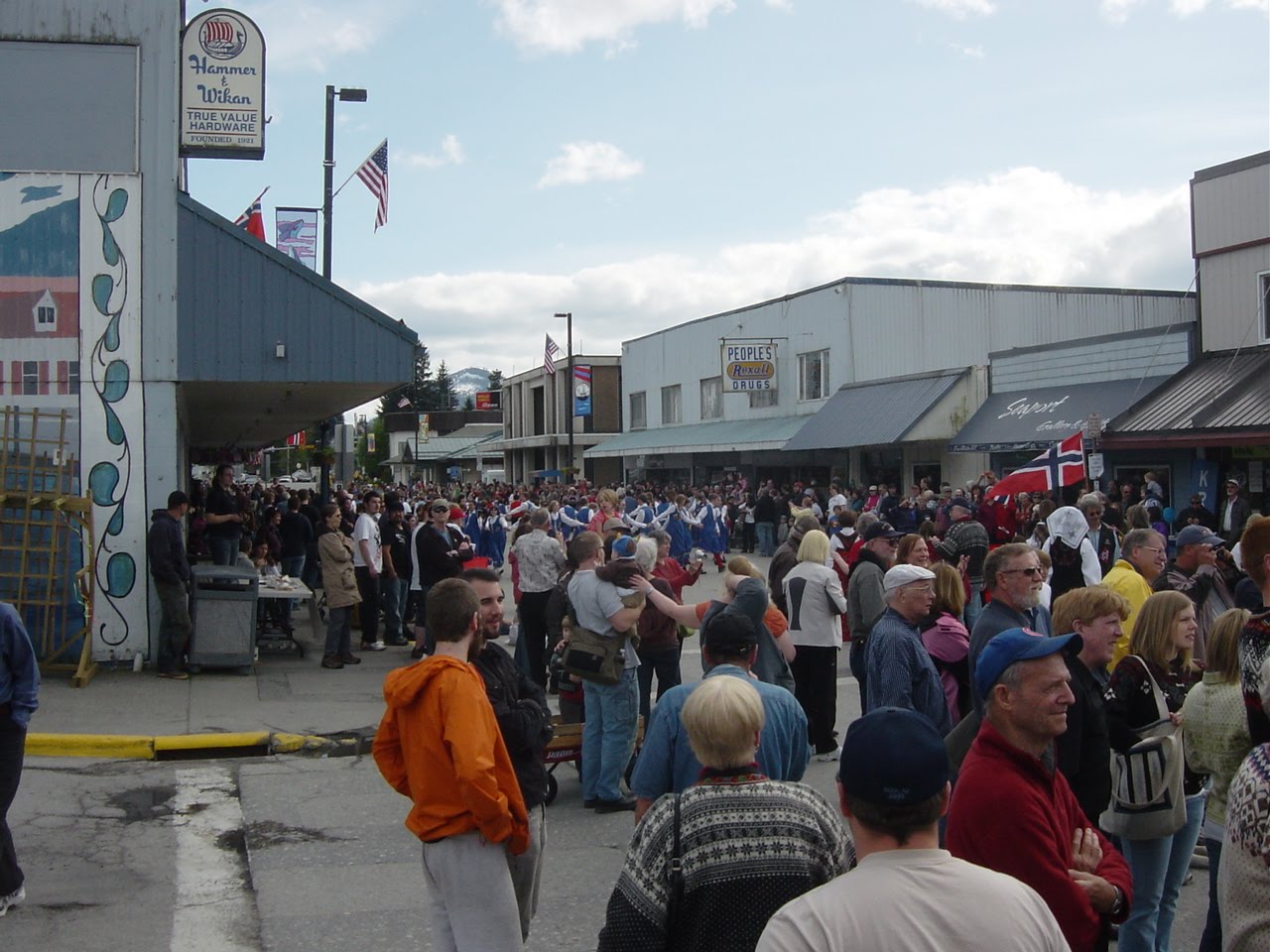
Little Norway Days or Mayfest as it has apparently come to be known by is a celebration Petersburg undertakes around May 17th, Norwegian Independence Day. This year the 17th fell on a Monday so whoever decides these things for Petersburg, probably the Chamber of Comix or maybe the Rotorooters, decreed the festivities begin on Thursday the 13th and conclude on Sunday the 16th. I wonder if the Norwegians celebrate their independence day by dressing up as Vikings and wander around downtown serving ‘warrants’ and imprisoning residents in a rustic compound amidst a ‘beer garden’. It was a good time, though. There was a variety of food booths and it’s always fun to be able to walk around drinking beer. I ran into several old friends at the Sunday fish cook out at Sandy Beach. Saturday was rainy but otherwise the weather was good.

The rest of the stay was spent doing chores: filling water tanks, grocery and liquor runs, laundry, etc. We finally left Wednesday afternoon. It was a beautiful three hour motor down the Narrows to Beecher Pass where we anchored up behind Keene Island.

Thursday was overcast with little wind. As we approached Duncan Canal the wind began to build out of the north to the point that when we turned south out of Beecher Pass it was blowing 10-12 knots. I waited until we were in Sumner Strait before coming up into the wind to put up the main. Miss Mercedes rested. We reached west across Sumner Strait on starboard tack until abeam Clarence Strait where the wind shifted to a reach on port tack almost all the way to Point Baker. We were tied to the state float in Point Baker before 1PM.

Point Baker is different from the other villages in Southeast I’ve visited. Tenakee, Elfin Cove, Pelican, Port Alexander, Baranof, even Funter have public uplands or boardwalks you can walk on. Not so, Point Baker. The restaurant, bar, laundry, store, fuel, post office, and fire house are all on floats and tied to the inside of the state float. There’s a rather unwelcoming sign on the gate that blocks access at the top of the ramp. Having seen Point Baker I made plans to leave in the morning.

The next morning as the engine was warming for departure I met Herb who apparently owns most of Point Baker. He’s very charming and we had a very pleasant conversation. After, as I was untying from the dock, I realized Herb probably had something to do with the sign that had such a negative effect on my impression of Point Baker.

We motored out into Sumner Strait under cloudy skies and calm wind. The track I had plotted detoured into Port Protection which is right around the corner from Point Baker. I wanted to see the village. We made a slow circle in the bight where the state float is. It didn’t have a ramp to the beach and all the other floats that did were private. Point Baker redux. We continued south. The wind was very fluky all morning never above 5 knots but predominately out of the west. There were whale spouts but they were all pretty far off.

Our destination for the night was behind the islands in Shaken Bay. My first track had us transiting Shaken Strait all the way around and anchoring in Calder Bay. This is the usual route through Shaken Bay and is recommended by the Coast Pilot. Instead we took the route between Middle and Divide Islands and anchored behind Divide Island.

By this time the wind had built to 20 knots. I was very confident of the set of the anchor but I wanted to see if there might be an anchorage more sheltered from the wind so after Jazz’s beach patrol we went exploring in the skiff. There weren’t any including Calder and by the time we got back to the boat the wind was dying.

Dry Pass at the north end of El Capitan Passage is much like Rocky Pass, narrow and shallow but much shorter. Our departure a little after 7 in the morning allowed us to transit on a rising tide and a favorable current and we arrived at the Forest Service dock below El Capitan Cave by 9AM.

I’m not a caver and didn’t know about El Capitan Cave until an acquaintance in Sitka told me about it, but it had a dock and I’m always interested in a cheap and easy means to get ashore. Jazz and I hiked up to the information kiosk-closed, and the outhouses-open. I didn’t know how far the cave mouth was so we just continued on. The trail quickly became stairs and 200-300 feet in elevation later we were standing in front of the cave mouth. I was wearing Teva sandals and had the little pen flashlight I carry in my jacket so I only ventured far enough in to where my penlight was overwhelmed, not very far.

We were underway by 11. The clouds had pretty much left by the time we made the turn to the south at Aneskett Point. The winds were calm for the remainder of the Passage but abeam Tenass Pass they were 8-10 knots SSW. It came and went as we wove our way among the islands northeast of Sea Otter Sound. It was still sunny in Tuxecan Passage but the wind freshened to 20 knots on the nose and low clouds blanketed the south. We were under the clouds when we got to our anchorage in Kaguk Cove. We were only partially sheltered from the winds but the water was flat and the anchor was deep in the mud.

Sunday morning was drizzly and calm. It remained calm until we turned south behind Harmony Island where the wind picked up to 6-8 knots out of the south of course. By the time we were behind Culebra and Saint Phillip Islands breaks in the clouds began to appear and the run through San Christoval Channel and across San Alberto Bay was under the sun. We were tied to the dock in Craig by 3:30.

We’ve been here two weeks. It doesn’t seem possible it has been that long. I did reconnect with my friends Karl and Jeri. They had me out to their beautiful house for a delicious salmon and venison dinner. Karl introduced me to a couple of his harbor buddies and one of them took us out to Noyes Island one afternoon. I’ve met several sailboaters both local and transient. The days have flown by.

One of the reasons for the delay in leaving has been the weather. We’ve had gales on the outside (where I intend to go) kicking up 12-15 foot seas all last week. We got some of the wind and a little of the rain but for the most part the weather here at the dock has been pleasant.

Another of the reasons for the departure delay is that this area is very attractive physically. The geography is clumps of wooded islands, small and large, separated by open bays and sounds making for very interesting and scenic boating. One drawback is the extensive logging that has scalped a lot of the hills. Still, it’s a pretty spot and I’ve been having some difficulty deciding where to go.

So, where to? My plan is to go down the outside of Dall Island, hook around Cape Muzon, and head northeast through Cordova Bay, then down and around Cape Chacon, up the east side of Prince of Wales and over to Ketchikan. How long? Weather and whim will tell. One thing is certain and that’s that cell and wifi are sparse to non-existent so I’ll be out of touch for a while.

The pics: some residents of Wrangell, Mayfest 2010, sailing in Sumner, the sign in Pt Baker (I think this guy got the same dictionary as the fellow in Sitkoh Bay), a couple of Pt Baker, a deer swimming from Divide to Middle Island, Dry Pass, El Cap Cave, the stairs to the cave, ¼ mile long dock Craig north harbor, south harbor.

ap

Wednesday, May 19, 2010

Chatham and Keku


What a run up Chatham Strait! We left Port Alexander under mostly cloudy skies and light winds. The seas were 2-3 feet with the occasional 4 footer out of the south. The forecast was for northerlies to 15 knots. My plan was to make for Warm Spring Bay 55 miles away depending on the conditions. I figured if the winds didn’t cooperate we could put in to any one of a number of good anchorages on the way.

Coming abeam Point Conclusion the winds were out of the northwest at about 5 knots. The batteries were low after almost two days at the dock in PA so I didn’t mind the light winds and Miss Mercedes grinding away. But wind is wind and these winds weren’t on the nose. I set the main and got almost a knot. As we moved past Port Conclusion the wind backed to the ENE. I let Otto steer and trimmed the main to the shifts. It proved to be the predominate pattern, with the wind more northerly as we approached one of the deep fjord/canyons indenting the east coast of Baranof Island, then shifting to the east as we went past.

To take advantage of the flood current and minimize the wind shifts I altered course out towards the middle of the Strait. Blue Note has two speed indicators: one is a paddlewheel under the hull, the other is the GPS. The GPS shows SOG, Speed Over Ground, which is the speed you are realizing along the track. The paddlewheel or more properly the speed log shows the speed of the hull through the water. The difference between the readings indicates the effect current is making on your progress. At the peak of the flood, the speed log was 1.5 knots below SOG, indicating a knot and a half boost to our forward progress.

Toward late morning the wind had freshened to 8-10 then 10-15 with gusts to 20. I unrolled the genoa. As I trimmed it in the engine began to pick up speed as the sails took the load. I watched the SOG as I throttled the engine back. It dropped from 8.2 to 7.5 at idle. I shut it off in spite of the low batteries. Aah quiet. Well not really. But bliss for sure. The wind in the rigging, the burble of the wake, and the intermittent grunt of Otto’s pump moving the rudder to keep us on course combined with 7-8 knots of speed made for a wonderful three hours.

As the day wore on the wind began to die. Reaching the mid point of the joining of Chatham Strait and Frederick Sound the tide changed. We had been motor-sailing for several hours making 5-6 knots and charging the batteries. I knew that as the ebbing current increased we would be fighting it under motor alone. I tucked in close to shore to minimize the current effect. Good call. There were several pods of humpbacks fishing in the area and the clouds had gone for the most part. We were alongside the dock in Baranof by 8 PM, having averaged almost 6 knots for the run!

We spent five days in Baranof. The good weather and great company kept us tied to the float. The days were spent soaking in the spring, hiking to the lake, meeting new friends, and in general just hanging out. I had already met John on the S/V Sara. He was busy moving back into his house in Baranof. I met Dave and Anke on the S/V Slacktide. They had just finished 7 months of caretaking the Baranof Wilderness Lodge and were readying their boat, a junk-ketch-rigged sailing barge for a summer cruise. Tom on a Roberts 38 was headed up to Glacier Bay to work as a pilot boat operator for the summer. The M/V Explorer IV, a 60 foot motor yacht crewed by a bunch of fun-loving Canadians from Whitehorse passed through on their way to Skagway.

As the days slipped by I began to rethink my next route and destination. Those of you who have been following this blog know my planned route from here was the reverse of the route I took when I left Petersburg last November, i.e., back through Frederick Sound. From there I planned to go down through the Wrangell Narrows to Wrangell. When I looked at the calendar I realized that if I reversed destinations and went to Wrangell first I would be in Petersburg for Little Norway Days, a fun time to be in Petersburg.

The shortest route to Wrangell goes through Rocky Pass in Keku Strait. My 2008 edition of Charlie’s Charts, a popular inside passage cruising guide says that Rocky Pass cannot be used because the navigation aids have all been removed. But my ten year old charts and six year old Coast Pilot Vol. 8 both show and describe the Pass in close detail. All the captains I talked to in Baranof had gone through several times, Tom on the Roberts and Craig on the Explorer IV just in the last day or two. They all said the nav aids were still there and that it was no problem. I pulled out the tide book.

Rocky Pass is the narrowest and shallowest section of Keku Strait, a N-S body of water separating Keku and Kupreanof Islands and connecting Frederick Sound to Sumner Strait. It shares tidal current characteristics with other N-S narrow channels: both flood and ebb tides flow to and from a center point from each end. The trick becomes arriving at that center point at high slack. That way you ride the flood tide current to the center point then ride the ebb current out the other end. There is a downside to this plan.

According to the Coast Pilot the center point is at various points between High Island and Summit Island. If you are travelling south and arrive at the tidal center point at high tide, you are on a falling tide when you get to Devil’s Elbow, a little over 2 miles south. Devil’s Elbow is a right angle turn where the channel is quite narrow and swinging wide or cutting the corner is not advised. I wanted the cushion of a rising tide through the Elbow in case I got stuck in the mud and was willing to sacrifice having to buck the current for a couple of miles to have it.

Further research revealed Stedman Cove to be a suitable layover anchorage. I plotted a route to there: 44 miles. A check of the tide book indicated a departure of a little before noon on Thursday would allow us to ride the ebb down to Point Gardiner, then the flood all the way to Stedman, arriving before dark. A plan with a departure time set I went next door to the Explorer IV to have dinner with the Canadians.

What a good time! Bombay Sapphire G & Ts, an excellent red, and one of the best steaks I’ve had in a long time complemented great conversation. One of the guys shared a similar work history with me and pretty soon we were swapping helicopter exploits and radio stories. One thirty came in no time. Good thing the sailing board was set for noon.

I missed Thursday’s dawn but it was nice by the time I rolled out of the bunk. After saying good bye to all my new friends and readying the boat for departure we left. I raised the main as we motored upwind down the Bay. The forecast was for northwest winds to 10 knots in both southern Chatham Strait and Frederick Sound. Turning the corner into Chatham Strait we got 10 knots out of the south. The wind lasted until we got to Point Gardiner then died. We motored across Frederick Sound with the wind filling in slowly from the northwest behind us. By the time we reached Cornwallis Point it was barely enough to keep the sails full. Two hours later we were at the entrance to Stedman Cove.

There are pitfalls to using electronic chart programs. One of them is that you are rarely looking at the whole chart. I am almost always looking at a small portion centered on where the GPS has located the boat. Even when I zoom out, I’m either not looking at things like the title area or the text is too small to read. With NOAA Chart 17372, this is a mistake. Unlike almost every other NOAA chart I’ve used, the soundings on 17372 are in feet instead of fathoms.

Imagine my surprise when after getting a little off course entering Stedman Cove the scare box was showing 10 feet. I looked at the chart and the boat was next to a 6. In a flash it dawned on me that the soundings were in feet! It explained why the Coast Pilot described the anchorage depth in feet instead of fathoms. Luck jumps to the rescue of stupidity again. We lived.

It probably doesn’t need to be said that with my increased knowledge of Chart 17372, I went back over my plotted route through the Pass that night. I always plot the deepest route so I didn’t change it by much but I did gain new respect for the morning’s navigational task.

Friday started out with clouds covering most of the sky but the forecast was for partly cloudy turning to partly sunny. The anchor was aboard by 6:30 and we were on our way. I had come up with the departure time based on a SOG of 4 knots. Once we were out in the channel I realized I had underestimated the effect of the flooding current. At the usual RPM setting we were making 5.5-6 knots. I throttled back, not wanting to be going that fast if I made a wrong turn.

There were a lot of turns. The route I had plotted had 85 course changes between Stedman Cove and Eagle Island. Remembering the horror stories I used to hear when I lived in Petersburg along with the comment in the Coast Pilot about the uncharted hazards on the edges of the channel, I really wanted to stay in the channel.

After a couple of hours, I relaxed enough to not panic when I saw 12-15 feet on the box or jagged brown rocks close enough to spit on. The bird life was intense. I spotted a harbor seal and a couple of river otters but not much else. The winds were calm and the clouds were clearing.

The approach to Devil’s Elbow from the north is on an easterly course across a reef that ranges from 6 to12 feet deep at mean lower low water. We were 20 minutes before high slack water. The box was indicating 15-25 feet on the approach. The turn to the south was easy to discern from the two green daymarks and a red can and we cruised right through.

We were out of Rocky Pass by a little after ten. I put Otto to work and began looking for an anchorage for the night. Red Bay looked to be a good one so I plotted a route to its mouth. The wind had picked up to 10 knots south. I set the main and we reached across Sumner Strait.

The entrance to Red Bay was a reprise of the morning’s activities but much shorter. We were anchored in the outer bay by 3:30. I launched the skiff and took Jazz to the beach. When we got back to the boat I decided to re-anchor in the back bay. I wasn’t comfortable with the way the anchor had set and the spot was open to the westerly wind that was blowing 10-12 knots. We moved. I felt much better when the anchor set in the gray mud with a satisfying jerk. After dinner Jazz and I explored the bay in the skiff. Back on board I had a G & T and watched the sun go down from the foredeck.

Saturday morning was gorgeous, the bay a huge mirror. We had a leisurely morning getting ready for departure, our destination Wrangell, a little more than 38 miles away. By the time the anchor was in its chock the wind had picked up to about 10-12 knots. I raised the main hoping to at least motor-sail through Sumner Strait. Alas, the wind died once we were out in the Strait and didn’t really help our progress all day. But it was warm and clear with big cumulonimbus clouds hanging over the islands. We were tied to the transient float in Wrangell’s north harbor by 6 PM.

The pics are the sailboats in Warm Spring Bay, a particularly narrow spot in Rocky Pass near the Summit, looking back after transiting Devil’s Elbow, the intrepid crew enjoying the sunset in Red Bay, the huge mirror, clouds over Zarembo Island, and the approach to Wrangell.

ap

Friday, April 30, 2010

Port Alexander


Friday. Rain and fog, mid 40s, light wind.

We’re tied to the State float in Port Alexander, having arrived yesterday afternoon. Gale warnings are posted for Chatham Strait. The heater is on, the cabin is cozy warm. Quicksilver Messenger Service is on the stereo. I just popped a bowl of Orville’s and opened a beer. Time to update the blog.

We left Sitka a little after 2 on Tuesday. A warm and partly cloudy day promised a pleasant trip. The winds were light but I was assured by a local that it would be blowing “out front.” As we cleared the breakwater and entered the Western Channel the wind died completely. All that remained were the long greasy swells rolling into the Sound from the west. The partly cloudy day turned to mostly cloudy then overcast. By the time we were in the lee of Biorka Island it was raining steadily. So much for promises and assurances.

Mercifully our anchorage at Goddard Hot Springs was only 16 miles from Sitka so we weren’t in it for very long. In fact the rain died as we entered the bight in front of the bathhouses. After the anchor was down I launched the skiff, loaded a towel and a change of clothes, and Jazz and I headed to the beach.

There are two identical bathhouses, each having a large oaken tub, filled by a hot water pipe and a cold water pipe. The water in the lower house was tepid with no flow out of the hot pipe. We hiked to the upper house. Wow, talk about hot! Try as I might I couldn’t get in. I couldn’t even leave my feet in for very long. Where’s the Goldilocks tub? I ended up draining about six inches out and turning off the hot water. After about 20 minutes I was finally able to enter it. Aah the miracle of hot water.

Well after I reached prune status I got out, got dressed and hiked back down the hill. On the way I spotted where one of the hoses had come apart at a joint. I pulled as much slack as I could and stuck them back together. By the time we got to the lower house water was flowing from the hot pipe.

The next morning Jazz and I checked the lower bathhouse. Yup, it too was now too hot to handle. Good deed done, we got back to the boat, loaded up the skiff and were on our way.

The forecast for the outside waters from Cape Decision to Cape Edgecumbe was for 10 knot westerlies, 8 foot seas, with a Small Craft Advisory posted due to seas. As promised, the wind was out of the west as we left Hot Springs Bay. In anticipation of a reach down the coast I set the main. But the joke was on me as with every turn through the rock pile to the south the wind was on the nose. There was a west swell but the seas could better be described as confused with a wind chop out of the south combined with the backwash off the rocks and islets.

The day however was warm and sunny. At one point we heaved-to to watch the humpbacks bubblefish. The motion was too rough though and the whales too far off for photography so we continued on.

My friend Carl on the F/V Last Dance had recommended Still Harbor just inside the southern point of Whale Bay as a good place to stay. We headed there. He was right, it lived up to its name after all the motion outside. But what an entrance. With the 8-foot west swell creating a washing machine like effect right at the mouth, followed by the serpentine course through the rocks, I could have made diamonds out of coal, if you know what I mean.

Thursday had the same forecast as Wednesday. We steeled ourselves for the motion to come. Yup same conditions: confused seas, wind on the nose, sunny and warm. As we angled for Cape Ommaney at Sealion Rocks the wind became favorable. I raised the main. We were still too close to the wind and it was too light to turn off Miss Mercedes, but the stabilizing effect was wonderful.

We shot the gap between Wooded Island and Cape Ommaney, made the five-mile downwind run and here we are at Port Alexander. I checked for cell phone coverage about 2 miles out and had it, but not in the inner bay. :-( I do have a wifi connection but not good enough to upload pictures. They will have to wait, probably for Petersburg.

The forecast for southern Chatham looks good for a morning departure. We are making for Baranof Warm Springs, hopefully to meet up again with Rory on the S/V Complice.

The pics are the full moon over the O'Connell Bridge in Sitka the night before leaving, the anchorage at Goddard Hot Springs, the lower bathhouse, sunset in Still Harbor, the next morning, Cape Ommaney (if you look carefully you can see sea lions hauled out just above the white water), part of the Port Alexander water front, Jazz beatin' feet for the beach.

ap

Monday, April 26, 2010

The captain lives up to his name and other adventures


Friday. Clear, 48, afternoon sea breeze to 15 knots.

We’re in Sitka. Got here Monday night. All the errands have been run, all the dockside tasks have been performed. All, that is, but updating this.

We got away from the dock in Funter Bay a little after 9. Winds were light and a high, thin overcast diffused the sunlight. As we exited the Bay my cell phone beeped, indicating a voicemail message. The missed-call log showed that Rory on the S/V Complice had just tried to call. I was pleasantly surprised when my return call went through. He said he and another boat, the S/V Allegro were headed to Kalinin Bay on the south side of Salisbury Sound, tomorrow. They were intending to stay a couple of days. I told him I would see what I could do to join them.

My plan was to overnight in Tenakee Springs, spend the next night somewhere in Peril Strait, arriving in Sitka on Friday. I plotted the course to Kalinin Bay: 101 miles. The trick was to find a place to stay the night that would pretty much split the distance in half, making two long but reasonable travel days. After pouring over the Coast Pilot, Sitkoh Bay on the east end of Peril Strait looked like the best candidate. It was 55 miles away and it had a State-maintained floatplane float. It’s not a good idea to tie up to a floatplane float, but I figured since I would be there shortly before sundown and away around 8 the next morning, the chances of interfering with a plane needing to use the float would be minimal.

By late morning the overcast had burned away and the wind had died completely. We motored south down Chatham Strait making 5.5 knots across a mirror-smooth waterway.

Shortly before 8PM the docks at the “village” labeled Chatham on the chart hove into view. There was a dilapidated fuel dock, an even more dilapidated cannery dock and a float with a sign saying, “Private Dock, No Tresspassing.[sic]” No floatplane float. The advantage of a float is that Jazz can get to the beach without my having to launch the skiff. A dock with a fixed deck and a tall skinny ladder is no help. There was a good anchorage a quarter of a mile away but it would have been dark by the time I got the boat anchored and the skiff launched to say nothing of the retrieval time needed in the morning. I decided to tie up to the float, since I was leaving the first thing in the morning and the only tresses I was passing were firmly attached to my head. :-)

Above the float, attached to the ramp was a very well-maintained house, several outbuildings and a not-as–well-maintained house towards the cannery. As dark settled over the Bay no lights were seen anywhere. I figured since no one had come down to protest my action, I was good to go.

Wrong. Three sharp raps on the hull woke me up. Light was streaming through the portlights, the clock read 6:05. I slid the hatch back to face an irate man of indeterminate age. His first words were, “Can’t you read?” pointing at the sign. I’ve found in these situations the least said is best. I let the misspelling go unmentioned. He proceeded to tell me that there was a video camera, motioning over his shoulder with his thumb and that the owner would call the troopers if I wasn’t out of there immediately. I told him it hadn’t appeared that anybody was around and asked him if I could take Jazz to the beach. He rolled his eyes and said I needed to move the boat right now.

We were underway fifteen minutes later. It was a beautiful day, clear, no wind, and blue sky. As we gained the channel in the middle of the bay, a thick fog bank 2½ miles ahead in Peril Strait came into view. I went below, double-checked the waypoints on our route and flipped on the radar.

We emerged from the fog around 11, not having met any other vessels. We were making a little less than 4.5 knots bucking the ebbing tide. My plan had been to leave Sitkoh Bay around 8 which would allow favorable currents most of the way through Peril Strait and hit Sergius Narrows after the peak current. Our forced leave almost two hours early would put us in the narrows right at or slightly before peak current. Oh well. At least it would be assisting us rather than against us.

Whew, what an understatement. We turned out of Adams Channel at Rose Island into pronounced whirlpools and eddies stirred up by the tidal current and into a 20 knot wind blowing out of the west, right on the nose. I took over steering duties from Otto for the 4.5 mile run down to and through the Narrows. Wow, what a sleigh ride. We averaged 7 knots to the Narrows and 9.8 knots going through. It was surreal making that kind of speed with the opposing wind whipping up whitecaps.

I knew with that kind of wind in Peril it was liable to be howling in Salisbury Sound. To prevent a repeat of the monitor swan dive, I unhooked it and stowed it below while the seas were still flat before Kakul Narrows. Sure enough, 25-30 knots with 8 footers rolling in was awaiting us. When I glanced down at the laptop to check my course across the north end of Sinitsin Island the screen was blank! The only recovery was to cycle the power. When I tried to reload the nav program it said it had performed an illegal operation and would close. I loaded my back up program. It showed the rocks off Sinitsin but nothing for Kalinin Bay. About that time Rory called on the VHF to ask if that was me coming out of Peril. He and Teka were just exiting Neva Strait. Perfect timing. Complice led the way into the bay with Blue Note right behind and Allegro following.

After setting the hook, I hustled to get the skiff launched. Jazz was beginning to whine about holding it for so long. We cruised over to see if Teka wanted me to take her dog to the beach as well. No good deed goes unpunished. As soon as we set off, her dog peed in the bottom of the skiff and moments later Jazz let loose with a poop. Sigh.

The rest of the afternoon and evening was delightful. John on the S/V Sara arrived at some point. We had a large predominately Mexican pot luck dinner on the Allegro. Then the instruments came out and the jams were on.

The next day while the others hiked over to Sealion Cove I worked to get the nav computer back on line. I was finally successful. It required reloading the program. Unfortunately I lost all of the routes I had accumulated to this point. Oh well.

Cory and Tom, part of Allegro’s crew had asked if Jazz might want to go on the hike. I knew he did. When he got back to the boat he could barely walk. Poor old guy. It’s sad to be confronted with the fact that a moderate 5 mile hike was too much for this 12 year old dog.

Before noon the next day, both the Allegro and the Sara were underway to Sitka. Rory was headed north to Glacier Bay and the weather outside was not forecasted to be favorable. I was in no hurry to be anywhere so we both stayed put. That afternoon, feeling somewhat restless, I decided to hike over to Sealion Cove. On the way to the beach I stopped at the Complice to let Rory know where I would be. He decided to go along. The weather was perfect for the hike. Sealion Cove has a beautiful sandy beach and while we were there, two right/left beach breaks. With the 3-4 foot surf, I was tempted to get in the water. Discretion and 45 degree water stopped that. By the time we got back to the boats, it was raining lightly.

Sunday the wind came up and kept us both in the bay. We had a tasty minestrone soup for lunch on Complice and buffalo burger tacos on Blue Note for dinner. Jazz recovered from his ordeal and had no problem going to the beach.

The next morning after Jazz and I had gone to the beach in the skiff I decided to run out into Salisbury Sound to see what the conditions were like. Even though the forecast was not very good, the seas were less than 2 feet and the winds were less than 15 knots. We decided to go, Complice north to Lisianski Strait, Blue Note south to Sitka.

The trip back to Sitka was mostly uneventful. I had decided to bypass Olga Strait by going through Hayward Passage instead. In the East Channel I almost hit a rock. Fortunately my luck held and no water was inadvertently let into the boat. We arrived at Thomsen Harbor about 7:30.

So here we are in Sitka once again. I had hoped to spend no more than 2-3 days but there was simply too much to do: water, garbage, laundry, groceries, liquor, oil change, as well as several other errands. The weather is absolutely perfect and is predicted to be so through tomorrow. The problem is I want to spend a couple of days going down the outside of Baranof and storm warnings are posted for Sunday. I also need to update this and install the new VHF radio I just purchased. We will sit tight. Maybe Monday. We’ll see. I think I’ll mosey over to the fuel dock in case the weather guessers are wrong and we can leave earlier.

EDIT: It’s Monday and we are making plans to leave in the morning. We had 55 knot gusts yesterday afternoon and last night. I was thinking about going into the open mic last night, but the winds and horizontal rain preempted. I just paid my harbor bill and will hit the rain locker and market tonight. The next port will be Port Alexander, probably by the weekend.

Pics are our wake in Chatham Strait, passing tresses in Sitkoh Bay, tide rips in Peril Strait, buoy at Sergius Narrows, the fleet in Kalinin Bay, Captain Rory, yours truly at Sealion Cove, flamingoes in Alaska??

ap